
Arresting aerial imagery has revealed both the beauty and instability of WA's coast, showing properties under threat from the Coral Coast to Perth.
Coastal erosion is a hot topic after the recent devastation to New South Wales properties in storm surges; at home, the state government has shelled out more than $30 million for coastal protection works in Busselton and Seabird, with tens of thousands more going on sand replenishment at tourist beaches.
But Nearmap, which snapshots urban (that is, largely coastal) areas for government and businesses to monitor environmental trends, has provided a fresh perspective.
Survey planes have taken data-rich photos, as high resolution as seven centimetres per pixel, identifying rapid erosion in some urban areas, and contrasting rehabilitation work in others.
Some shots show the erosion of the coastlines at Bluff Point and Drummond Cove, both north of Geraldton, between 2013 and 2016.
The Shire of Geraldton recently spent $50,000 on an emergency sand dump at Drummond Cove, which Lands Minister Terry Redman visited to see the threat for himself.
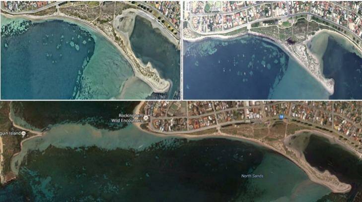
Other shots show dramatic imagery of Shoalwater Bay, near the departure point for the Penguin Island ferry, between 2009 and 2016.
Scientists have long known these problems are widespread and have traced many back to the flow-on effects of offshore coastal structures such as marinas and breakwaters - but what's happening at Shoalwater is all-natural, according to coastal oceanographer Charitha Pattiaratchi.
The Professor, head of the University of WA's School of Environmental Systems Engineering, pointed out the spit immediately to the southeast of Shoalwater Bay.
"Sand transport is like a bank account. You spend it and it goes somewhere else, there's erosion and accretion," he said.
"You see erosion from that point, but it contributes to accretion on that sandbar which didn't used to exist.
"You see there now a boat ramp that leads to more grass and a jetty that ends on land.
"In 1839 when it was first surveyed, the spit – the Tern Island sandbar – was there. In 1859 it disappeared. Then it appeared again. It has been oscillating like this ever since the 1840s – it's a highly dynamic area. In 2004 it was gone again."
But none of this was due to human mischief, he said, with the sand from the eroding point at Shoalwater naturally feeding the sandbar.
"This is just the wave climate around the different islands," he said.
"That whole area, the islands, the shores, are highly dynamic and unstable."
This could be small comfort to the residents of Shoalwater, whose buffer has shrunk from about 120 metres or so in 2002 to about 75 now.
State planning policy directs authorities to take into account long term erosion, storm events and projected sea level rises in determining property setbacks, but a bone of contention in some planning applications was was determining the "zero value" of the shoreline to measure from, Professor Pattiaratchi said.
"There in Shoalwater it has changed roughly 50 metres in just over a decade," he said.
"It's all cyclical. So where does your planning document start from?
"The problem is that people will essentially build where they want to. Then their houses will be under threat and then they will build a seawall.
"And so it goes."

